Showing posts with label GEOGRAPHY AND HISTORY ACTIVITIES. Show all posts

Wednesday, 21 June 2017

SELF-ASSESTMENT

Resultado de imagen de self assessment


I think this Term I did better than the second because I have worked-hard and I learned a lot of new expressions, grammar, vocabulary and now I participate more in class.

Tuesday, 28 March 2017

BOSTWANA PROJECT

This is the link of our project of Bostwana:
https://drive.google.com/drive/folders/0BzzegLLdJmjUcEFkYk1rYjgyMVE

SELF-ASSESMENT

  • What can I do that I couldn't do before?
  • I can talk better.
  • What did I like most?
  • The think I like most was the lesson why did you said that...? with Clarissa.
  • What did I do well?
  • I paid more attention in class.
  • What did I do in English outside the class?
  • I played games in English, I did my English homeworks, I did the project of Bostwana with Javi and JuanPi and I listened to music in English too.
  • What do I need to improve?
  • I need to improve the Reading.
  • What did I learn about culture?
  • I learned about Frank Abagnale and David Hampton and I learned a lot of things about of Bostwana.


Sunday, 19 March 2017

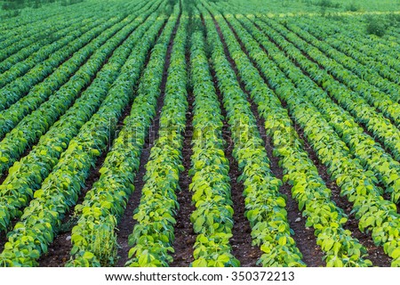
AGRICULTURAL LANDSCAPE

Resultado de imagen de agricultural landscape
In this picture you can see:
-I think is an open field because there aren´t boundaries.
-It is a monoculture farming becausev there is only one type of crops.
-I think is a dryland farming, that the fields need rain.
-I think is an extensive agriculture is aa sparsely populated area.

Monday, 16 January 2017

GEOGRAPHY-AFRICA VIDEO

ANSWER THE FOLLOWING QUESTIONS

  1. Where in the world is Africa?
  2. How many times is Africa larger than The United States?
  3. How is the savanna defined in the video?
  4. Which animals can be found in the savanna biome?
  5. Where is located the chaparral biome in Africa?
  6. Which are the most famous deserts in Africa?
  7. The main natural resources mentioned in the video are .....
      1. Africa is located in the southwest of Asia and in the south of Europe.
      2. Africa is three times the size of the United States.
      3. The savanna is the wild open grasslands of Africa.
      4. You can find elephants and giraffes.
      5. The chaparral biome is located in the norther coast of Africa and some at the south of Africa.
      6. The most famous deserts in Africa are the Sahara desert, the Namib desert and the Kalahari desert.
      7. Gold mines, oil and the rober trees.

FIND THE MISSING WORDS
1.  Africa runs 5 000 miles from the Mediterranean sea all the way down to the cape of good hope and 4 600 miles from  the cape Verde  all the way over to Somalia.
2.      Biomes are climate zones and throughout that area, throughout that  region  , you can see the same average  temperature and average  precipitation  what that means is that you also see very similar animals and plants  living in that region.
3.      The most famous desert in Africa is, of course, the Sahara desert. Now, some parts of the Sahara desert are   sandy  , like you can see here. Other parts of the Sahara desert are  rocky  but in either case, the fact that it is very  dry  is going to make it a very difficult barrier to cross.
4.      It is not the  rain  itself that’s particularly important, it’s also the biodiversity. There are many different  plants and animals   That can be found in the rainforest   and that’s one of the thing that makes the rainforest so  variable not just in Africa but throughout the Earth.
5.      The  Nile  is the most famous river in Africa, because is the  longest river in the world. But there is also the  Congo river  which is the  second longest river in the world.
6.      Africa actually has its own version of the  Great  Lakes with famous lakes like Lake Malawi  lake Victoria and lake  Tanganyika .
7.      All the Africa is a plateau. Meaning that Africa itself is an   elevated   land. But that doesn’t mean you can’t find any   mountains in Africa. You can find mountain ranges like, for example, the Atlas in northwestern Africa.
8.      Africa also has some interesting mountains like  Kilimajaro  mountain , the highest  peak in Africa which seems to just  rise on it own out of the  ground.
9.      The Great Rift Valley refers to a region of Africa that is  literally, being  split apart. There are some  tectonic plates  that are located within or near Africa, that are, actually,  moving away from each other, and what’s doing is creating not just some of the highest  elevations in Africa, but also lakes like  Tanganyika that is among the  deepest in the world.

Thursday, 15 December 2016

VALLADOLID

The 2nd of November we went to Valladolid, we went with Gemma (teacher of music), Teresa (teacher of geography) and with Luis (teacher of biology). First we went to the centre of Valladolid and we had free time. Then we went to see a contemporany music concert, at the begining of the concert I didn´t like it so much but the end was great. After we had some time for lunch, I was really hungry.The wine museum was a bit small but I like the smell part. Then we went to visit the Peñafiel castle, I like it so much, the views were awesome.
I think the best part of the journey was the Peñafiel castle, I enjoy it alot.

Peñafiel castle


Tuesday, 1 November 2016

KOSCIUSZKO NATIONAL PARK

LOCATION:
The park is located in the southeastern corner of New South Wales, in the southwest of Sydney.


CLIMATE:
The highers regions of the park experience an alpine climate which is unusual on mainland Australia. However, only the peaks of the main range are subject to consisten heavy winter snow. The climate station at Charlotte Pass recorded Australia´s lowest temperature of -23ºC  on 28 June 1994.

FAUNA:

Corroboree Frog : 

Mountain Pygmy Possum : 


Dusky Antechinus: 


Wild Horses: 

VEGETATION:

Snow Gum: 

Chinese Elm: 

Tuesday, 4 October 2016

GEOGRAPHY GLOSSARY

Geography: Is the scientific study of places.
General Maps: Are representations of the Earth that show a group of characteristics which are very varied.
Thematic Maps: Show the spatial distribution of specific aspects of the land.
Earthquake: Vibrations in the earth's crust causing the ground to shake.
Cartography: Is the discipline that is concerned with representing territories
Scale: Is a proportional relationship existing between what is represented on the map and reality
Archipielago: A group of islands
Valley: A long narrow area that is lower than surrounding uplands, hills, or mountains.
Hill: A natural elevation of the earth's surface, smaller than a mountain
UNIT 2:
Demography: Is the science of populations. Demographees seek to understand population dynamics by in vestigating three main demography processes : birth, migration, and aging (including death). All three of processes contribute to changes in populations, including how people inhabit the earth, form nations and societies, and developed cultures.
Destination: Destination can be regional; continental or intercontinental.
Overpopulation: When the populations exceeds the capacity of a country or a continent

Population pyramids:


UNIT 3:
Turbot-mejillones
Sea bream-besugo
Sea bass-lubina
Hake-merluza
Whiting-pescadillo
Cod-bacalao
Rubber-caucho
Fir-abeto
Birch-abedúl
Yield-production
Grazing-pastar
Herds-rebaño
Sorghum-sorgo
Peach-melocotón